The Big Picture
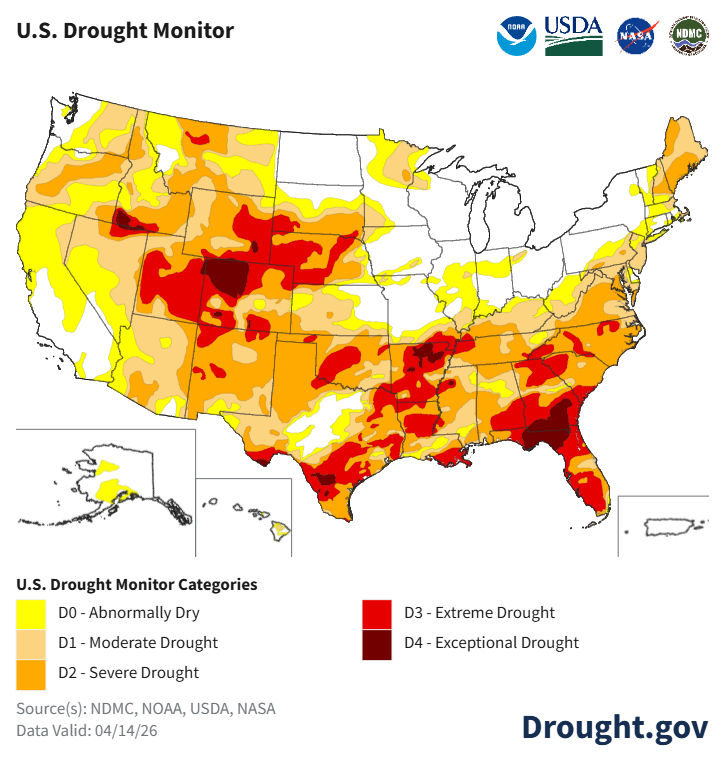
As of April 14, 2026, according to the U.S. Drought Monitor, 51% of the United States and 61% of the lower 48 states are in drought. That's up 1.6% from last week and up 11.3% from last month. The number is going in the wrong direction, and it's going there fast.
To put that in human terms: 148.8 million people live in areas currently experiencing drought. That's about 45% of the country's population. Forty-five states have areas in moderate drought or worse.
By the numbers
51% of the U.S. is in drought
61% of the lower 48 states
148.8 million people affected
45 states experiencing moderate drought (D1) or worse
Up 11.3% from just one month ago
Wait, How Do We Measure Drought?
Think of it like a report card for rain.
The U.S. Drought Monitor is a weekly map produced by NOAA, the USDA, and the National Drought Mitigation Center. It looks at rainfall, temperature, soil moisture, streamflow, reservoir levels, and reports from local observers across the country. Then it grades every part of the U.S. on a scale:
D0 (Abnormally Dry): Conditions are drier than normal. Going into or coming out of drought.
D1 (Moderate Drought): Crops and pastures are stressed. Water levels are dropping.
D2 (Severe Drought): Crop losses are likely. Water restrictions may start.
D3 (Extreme Drought): Major crop and pasture losses. Water shortages are widespread.
D4 (Exceptional Drought): The worst category. Widespread water emergencies.
The Drought Monitor has been publishing these maps every week since 2000. When scientists say "this is the worst drought since the Drought Monitor began," that means in over 25 years of tracking, they've never recorded conditions this bad in that region.
The Southeast: The Worst of It
The hardest-hit region in the country right now is the Southeast. According to a NIDIS drought status update published April 16, 96.83% of the Southeast is in moderate to exceptional drought. More than 81% of the region is in severe drought or worse. This is the largest area of drought in the Southeast since the U.S. Drought Monitor started tracking in 2000.
The dry conditions started building in late summer and early fall of 2025. By now, the entire Southeast has precipitation deficits going back nine months, to July 2025. For most of the region, that means 8 to 16 inches less rain than normal.
How dry is it?
According to NOAA's National Centers for Environmental Information, Georgia, North Carolina, and South Carolina have experienced record dry conditions for the September 2025 through March 2026 period, with records going back to 1895. That's 131 years of data. This is the driest that stretch has ever been in those three states.
Other states in the region are also seeing historically dry conditions for the same September through March period. According to the NIDIS update, it was the second driest on record for Alabama, third driest for Florida, ninth driest for Tennessee, and tenth driest for Virginia.
Every single state in the Southeast has seen drought conditions worsen over the past four weeks. North Carolina is 100% in drought. Virginia is at 99.95%. South Carolina is at 99.34%. Florida is at 98.99%. Georgia is at 98.13%. Tennessee is at 93.65%. Alabama is at 88.66%. Parts of Tennessee saw a 3-category degradation in just four weeks, jumping from abnormally dry (D0) to extreme drought (D3).
What Does This Actually Mean on the Ground?
Drought is not just a number on a map. It's farmers looking at soil too dry to plant seeds in. It's ranchers feeding hay to cattle in April because the pastures have nothing left to graze. It's stock ponds drying up and irrigation water running short.
According to the April 16 NIDIS drought status update, conditions across the Southeast are hitting multiple sectors hard.
Agriculture
Soil moisture is limited or nonexistent across much of the Southeast. Seeds can't germinate in dry soil, and in some areas it's too dry to plant at all. Crops that are in the ground need irrigation to survive. Pastures have been in poor condition since fall 2025, forcing livestock producers to keep feeding hay, which is expensive and was supposed to stop months ago.
Fire risk
The persistent dryness has built up dry fuel on the ground across the region. According to the National Interagency Coordination Center's Wildfire Potential Outlooks, there's a greater-than-usual likelihood of significant wildland fires across much of the Southeast in April, with portions of the region remaining at above-normal risk through May and into June.
Water supply
Streamflows are well below normal across the entire Southeast except for the Florida peninsula. Some areas are seeing below-normal groundwater levels. Reservoirs are lower than usual for this time of year. All five of Florida's Water Management Districts have put water conservation measures in place for parts of their service areas. Typically, the December-through-March period is when the Southeast "recharges" its water resources. That recharge didn't happen this year.
It's Not Just the Southeast
While the Southeast is the most dramatic story right now, drought is affecting large swaths of the country. According to the Drought Monitor, drought has worsened across the South, Mid-Atlantic, Lower Midwest, and scattered areas of the High Plains and West. Texas, Florida, Iowa and surrounding states, and a small area of California saw some improvement, but the overall national trend is toward expansion.
The Western U.S. is also dealing with drought and snow drought conditions. A NIDIS snow drought update from April 9 noted that much of the West is entering its warm, dry season, and relief depends on late spring storms and monsoon activity. The worst impacts are expected in parts of the Pacific Northwest, the Rio Grande Basin, and the Colorado River Basin, areas that have dealt with consecutive years of drought and are starting this spring with water storage deficits that are expected to get worse.
What's a "snow drought"?
In the Western U.S., mountain snowpack acts like a giant natural reservoir. Snow piles up in winter and melts slowly through spring and summer, feeding rivers, filling reservoirs, and supplying water to farms and cities downstream. A "snow drought" happens when there isn't enough snow, or when warm temperatures melt it too early. Either way, less water flows downstream when people need it most.
Why Is This Happening?
Drought is fundamentally about precipitation deficits. It hasn't rained enough, for long enough, over a wide enough area to keep up with demand. In the Southeast, the deficits started building in July 2025 and have been compounding ever since. A normal winter would have helped recharge soil moisture and refill streams and groundwater. That didn't happen.
On top of the lack of rain, temperatures matter. Warmer-than-normal temperatures increase what scientists call "evaporative demand," which is basically the atmosphere's thirst. When the air is hot and dry, it pulls moisture out of the soil, out of plants, and out of open water faster. Even when it does rain, high evaporative demand means less of that water actually makes it into the ground or stays in reservoirs. According to the April 16 NIDIS update, evaporative demand across the Southeast is forecast to be extremely high for this time of year over the next two weeks.
What's the Forecast?
Not great. At least not in the short term.
According to the NIDIS update, limited or no rainfall is expected across most of the Southeast over the next seven days. Only parts of central and western Tennessee are forecast to get more than half an inch, which is below normal. NOAA's Climate Prediction Center slightly favors above-normal precipitation for much of the region in the April 21-27 window, which could bring some relief. But above-normal temperatures are expected for the next two weeks, which will counteract some of the benefit of any rain that does fall.
The seasonal outlook is a mixed picture. NOAA's Seasonal Drought Outlook forecasts drought to improve or end across parts of Florida, southern Alabama and Georgia, and some coastal areas. But for the rest of the Southeast, drought is expected to persist. The fundamental problem is that the region needs a sustained period of soaking rains to recharge soil moisture, streamflows, and groundwater. That's hard to get in late spring and summer, when rainfall typically comes from isolated thunderstorms that dump a lot of water in one spot but miss everything around it.
What this means for you
If you live in the Southeast or other drought-affected areas, check your state's drought conditions at drought.gov. Follow any local water restrictions. If you're on a well, monitor your water levels. If you're in an area under a burn ban, follow it. And if you're a farmer or rancher, contact your local USDA Service Center for information about drought assistance programs.
Sources: U.S. Drought Monitor, Current Conditions (April 14, 2026); NIDIS, Drought Status Update for the Southeast (April 16, 2026); NOAA NCEI, Statewide Precipitation Rankings; NIDIS, Snow Drought Current Conditions and Impacts in the West (April 9, 2026); NIFC, Wildfire Potential Outlooks; NOAA Climate Prediction Center, Seasonal Drought Outlook. Have a correction? Contact us.